The simulation is based on a request in a thread a about LPWAN on LinkedIn. A simulation of an LPWAN gateway on Mount Arapiles in Australia was requested. The height of the gateway antenna above ground was set to 25 m before in other simulations. The height of the antenna at the sensor was set to 1 m. This 25 m height and on 1 m height repeat themself again and again in other of our simulations. This makes the simulations comparable. 25 m is a realistic practicable height for an antenna for a gateway. Approximately 25 m height can also be found by checking the height of the LTE base stations in German cities online at the Federal Network Agency. In total, the height of Mount Arapiles and the antenna mast of 25 m height results in 364 m. There was a simulation of an LPWAN gateway to the castle keep of Gleiberg Castle in Germany at 331 m altitude. However, the difference in height between the two LPWAN gateway antennas is not very big. The difference is that in a near of 3.5 km from the keep of Gleiberg Castle there is already a mountain range with a mountain called Königsstuhl (348 m). Around the castle are after approx. 3.5-5 km distance immediately again some mountain chains. As in Australia on Mount Arapiles, the ranges cannot be repeated in the low mountain regions of Germany.
LPWAN Link in Australia with 25 m tower on a mountain and 1 m high node antenna
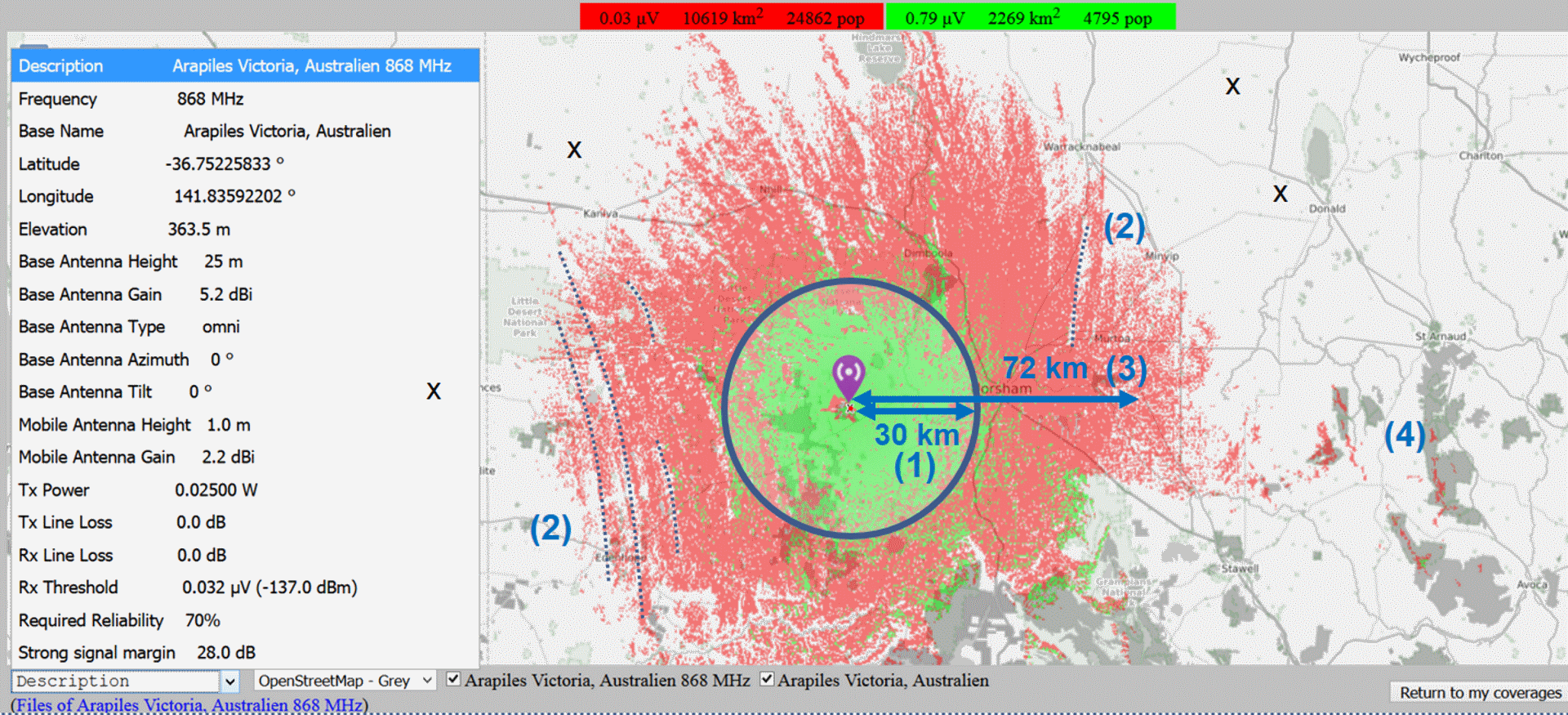
LPWAN at Mount Arapiles in AU
It can be seen that at a distance of approx. 30 km the maximum range for indoor coverage has been reached. The town Horsham (1) is located shortly before this imaginary 30 km radius. The zoom view is showing that the color of the simulation changes from green to red with the construction line of the village. In the simulation it was specified that the maximum link budget of 158 dB 28 dB should be subtracted from the maximum link budget for loss due to fading and the first wall of the buildings. Since the simulation software knows the vegetation and the buildings, it uses a higher attenuation for the simulation for towns. If we calculate the maximum theoretical visibility at the beach in Australia with 364 m eye height and 1 m height for the antenna of the node, then we get 72 km. But in the simulation the radio wave reaches further than 72 km (3). The software calculates with the so-called radio horizon, which is on average 1.33 times further away than the visible horizon. This so-called k-factor with 1.33 is included in the simulation. The k-factor is depending on the soil condition and can also be larger or smaller than 1.33. The k-factor is calculated in the simulation. The effect of the k-factor on the simulation has already been explained in a previous chapter. The simulation also shows multiple arcuate white stripes (2) without radio coverage. Those areas have been highlighted with dotted lines at some points in the show graphic. These arc-shaped areas indicate mountain chains in the region. At a distance of over 100 km the simulation shows red dots for radio coverage. These far away points with radio coverage indicate the presence of mountains.
LPWAN Link in Australia with 25 m tower on a mountain and 1 m high node antenna – zoom in
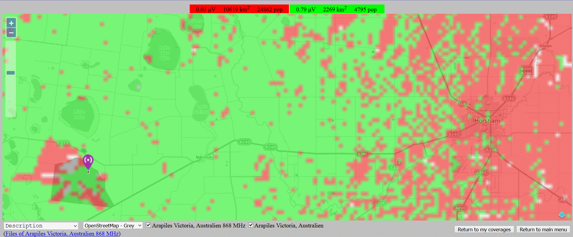
LPWAN in AU zoomed in
In the detailed view we can see that in a short distance to the antenna some areas are already marked white and therefore not covered by the Gatway. By looking at the contour lines of Mount Arapiles or looking at pictures in the internet, we can see that there is a height difference of 100 m on a distance of 350 m. On this steeply decreasing mountain, a radio shadow develops. The region is a paradise for climbers.
2D profile of the LPWAN link from the hill to the town
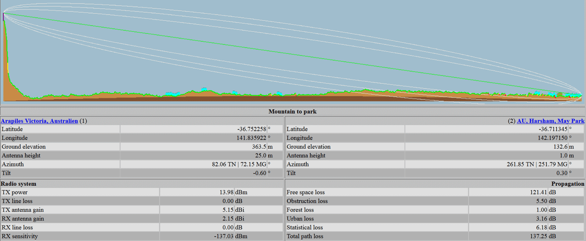
LPWAN link from hill to the town
LPWAN parameters at Mount Arapiles
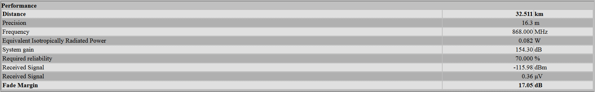
Furthermore, there are some green areas in the middle of the town. Despite the buildings, these green areas point to a radio coverage. By taking a closer look at the town, we notice that there is a horse race track at the place where the large green area is shown. Another green area with radio coverage is the Park May. Naturally, there are no buildings in this park. That’s why the software calculates a radio coverage in the middle of the town. In order to analyze this again more exactly a radio link with profile was calculated from the mountain into the park. We see that the so-called Fresnel zone is cut on about two thirds of the way. With the 364 m high transmitter mast for the gateway, we have almost a line of sight into the park. Since the radio wave not only travels in a straight line over the line of sight, but also over the curved line of the first Fresnel zone, a supply in the park is possible. The area marked green shortly before the park marks the horse racetrack. The horse racecourse has an extension of about 420 m in north-south direction and about 200 m in west-east direction. The areas marked in light blue show us the buildings in the village. The light blue marked area at 10 km distance from the mountain with the gateway shows us the village Natimuk.
Summary:
Such extremely high locations with an altitude difference of approx. 230 m and an almost free view of over 50 kilometres will rarely be found in Germany. In the Netherlands we probably have the free view but we lack the mountains. There you have to use masts and high buildings to install gateways and base stations. The marketing teams of the LPWAN companies in the unlicensed band always refer to a range of 45-50 km. This simulation shows that even at extremely high locations these ranges cannot be realized for indoor coverage. In general, the simulation shows us that a range of approx. 60-70 km is reduced to approx. 30 km. In the urban area we are forced to use sites about 25 m high. In Hannover you pay 300 € rent per month on a site about 25 m high. The possible high locations have 95 m height and cost 3000 € rent per month. In other countries the renting costs are perhaps more favourable. A local LPWAN for a public utility or a city will probably be located on inexpensive own buildings. If you then have to add sites you will avoid the 3000 € rent per month on the 95 m high building. There is a difference of about 28 dB between indoor and outdoor coverage. The simulation shows that in addition to the 28 dB in the first wall and fading, the path loss in the open space of 121 dB is also caused by building and vegetation losses.
References and remarks:
Climbing Mount Arapiles: https://www.trailhiking.com.au/mount-arapiles-gully-tracks/
K-Factor: http://www.gsm-modem.de/M2M/m2m-faq/lpwan-gateway-middle-north-sea/
Fresnel Zone: http://www.gsm-modem.de/M2M/m2m-faq/lpwan-gateway-fresnel-zone/
Range of LPWAN: http://www.gsm-modem.de/M2M/m2m-faq/lpwan-range-comparision-nb-iot-lorawan-sigfox/
LPWAN Gateway at Gleiberg Castle: http://www.gsm-modem.de/M2M/m2m-faq/lpwan-gateway-gleiberg-castle/
Anyone who is planning their own private LPWAN is welcome to contact us. We would be happy to explain how to use the software to simulate a wireless network in workshops or online seminars. If you don’t plan your own network and want to use an existing one and want to develop your own PCBs for this purpose, please do not hesitate to contact us. We are happy to share our experience from the numerous LPWAN projects with you. Please send your requests to harald.naumann(at)lte-modem.com